Possible flooding
Extreme precipitation events are expected to become more frequent in the future. The amount of annual precipitation will increase, as will the intensity of the showers. The purpose of the flood stress test is to gain insight into where rainwater flows when extreme precipitation occurs and what bottlenecks will occur when the sewer system and soil can no longer handle it. The Map shows where water remains and how deep the puddles are.
Flooding stress test results
View flooding stress test results in the map viewer.
Extreme Precipitation
3 different showers were calculated for the municipality of Geldrop-Mierlo:
1. The shower that actually fell on the night of June 17-18, 2020; 87mm in 5 hours;
2. A downpour that occurs once every 500 years; 90mm in 1 hour;
3. A downpour that occurs once every 2,000 years; 160mm in 2 hours;
The fact that the chance of extreme precipitation is small does not mean that this type of rainfall is very rare in the Netherlands. Because the area where such a shower falls is very localized, there can be many places where such a shower can fall. This type of shower falls somewhere in the Netherlands every year (just look at how often the media pays attention to flooding after extreme showers). So an extreme shower is relatively likely to fall somewhere in the Netherlands, but the chance of it falling exactly in your street is very small. It is always about the probability of the shower occurring. It could just happen tomorrow. And the day after again. The probability says nothing about how often it actually occurs.
Due to climate shifts, extreme showers are going to become more frequent. By the year 2050, that 160 mm shower may occur once every 500 years. The probability of such a heavy downpour occurring is therefore much higher. The Maps show how the probability of flooding will develop in the coming decades.
What do you see on the Map?
Our municipality resembles a flat pancake. But even like a pancake, there are small differences in elevation. When there is extreme precipitation, at some point the sewer system can no longer process the water. The water that cannot be processed flows to the lowest point which can lead to inconvenience. This often lasts at most a few hours because after that the water still flows away via the sewer system.
The Map shows with colors where water remains during extreme precipitation. The darker the color blue, the more water there is. The situation sometimes appears more serious on the Map than it is in practice. If a street is colored dark blue on the Map it does not mean that water is flowing into homes. It depends on the elevation of the house in relation to the road.
Because of the limited accuracy of the elevation map, the Map at plot level should be interpreted with some caution. Small differences in elevation can make all the difference here. On-site investigation is always required.
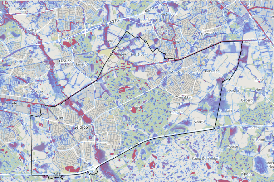
During extreme precipitation events, water often enters homes through toilet bowls or scrub holes. On the Map , this is not visible. This nuisance is mostly related to the aeration and venting of the house sewer system and usually not to the elevation of land or house.
What can we do about it?
The municipality invests a lot of money every year to make sure the sewer system continues to work properly. And despite that, it can still happen that, for example, a drain is clogged by leaves or dirt. This cannot be prevented and often only becomes visible when it is too late. Report this situation to the municipality so we can do something about it.
The sewer system is not designed to handle extreme showers. Many sewers date from 1960-1980 and were designed with the standards of that time. With today's knowledge, we would probably do things differently. It is incredibly expensive and therefore not possible at this time to adapt the entire sewer system at once. But in the coming decades this will happen gradually.
District design choices were often made in the distant past that now result in flooding. Again, the point is that we would do things differently with today's knowledge. It is often difficult to change this and, moreover, it involves a lot of expense. But with targeted local research, solutions can often be found. For example, by diverting the water to other low areas or by building storage basements.
Even in the design of individual homes, choices were sometimes made that now result in a high risk of flooding. These include sunken garages, basements but also building levels that are too low in relation to the surroundings. It is often extremely costly to adjust this if at all possible.
Today's trend of paving gardens is leading to more and more flooding. In some streets, the paved surface area has even doubled. The capacity of the sewer system cannot cope with this. By greening your garden or at least choosing permeable material, you are helping to reduce flooding. For greening your garden you can receive municipal subsidies. One garden does not make the difference, but all gardens together do.
At the edge of built-up areas and in the outlying area, rainwater is often drained through ditches. It is very important that the ditches remain open. The municipality mows the ditches regularly. By keeping the verges low, the water from the road can run into the ditches.
The height differences in our municipality are small. During heavy rainfall, the water board's ditches are often completely full as well. Often the surrounding land then floods. Therefore, in neighborhoods such as Luchen, large storage ponds are constructed to temporarily store water.
What did we do?
In response to flooding in 2020, a working group began working with residents to find solutions to the nuisance. This resulted in a large number of projects currently in preparation or already implemented. Some of these we mention here:
- Underground water storage cellars will be constructed in Parallelweg, Bisschop van Mierlostraat and Neerakker.
- Ponds in the form of ponds will be created in the Neerakker, Heer Dickbierweg, near the Beemdstraat and near the Ori.
- At several homes, the driveway will be modified to stop the influx of stormwater.
Some 5 other locations are still being studied for the best measure.
You can read more about this topic on the approach-waterlogging and approach-waterlogging-2020 page.